
Garden Map Co-ordinate Trail
Garden Map Co-ordinate Trail
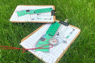
In the classroom we will look through the different features of maps including symbols, scales, orientation and co-ordinates. Working in pairs, pupils will use a map and compass to find features within the grounds using co-ordinates.
Learning Objectives
- To understand that a map is a birds eye view of a place at a smaller scale.
- To recognise different features on a map using the symbols and begin to relate what is shown on the map to what they can see.
- Use simple coordinates (or four-figure grid references) to locate points (or areas) on a map.
National curriculum links
Geography
Geographical skills and fieldwork
- use maps to locate countries and describe features studied
- use the eight points of a compass, four and six-figure grid references, symbols and key to build their knowledge of the United Kingdom and the wider world
Mathematics
Y5 Geometry – position and direction
- continuing to use a 2-D grid and coordinates
Y6 Geometry – position and direction
- describe positions on the full coordinate grid
PSHE guidance
- to equip pupils with a sound understanding of risk and with the knowledge and skills necessary to make safe and informed decisions


